The hardware and bandwidth for this mirror is donated by dogado GmbH, the Webhosting and Full Service-Cloud Provider. Check out our Wordpress Tutorial.
If you wish to report a bug, or if you are interested in having us mirror your free-software or open-source project, please feel free to contact us at mirror[@]dogado.de.
![]()
![]()
The wikilake package provides functions to scrape the
metadata tables from lake pages on Wikipedia.
install.packages("wikilake")
devtools::install_github("jsta/wikilake")
library(wikilake)
#> Loading required package: maps
# metadata only, see units of numeric fields with wikilake::unit_key_()
lake_wiki("Lake Mendota")
#> Retrieving data from: https://en.wikipedia.org/wiki/Lake_Mendota
#> Name Location Type
#> 1 Lake Mendota Dane County, Wisconsin,United States Natural freshwater lake
#> Primary inflows Primary outflows Catchment area Basin countries Max. length
#> 1 Yahara River Yahara River 562 United States 9.04
#> Max. width Surface area Average depth Max. depth Water volume Residence time
#> 1 6.61 39.41654 12.8 25.3 NA 4.5
#> Shore length1 Surface elevation Frozen Lat
#> 1 34.8 259 December 20 (average freezing date) 43.1066
#> Lon
#> 1 -89.4247# use the clean = FALSE argument to get raw data
# (i.e. avoid parsing of numeric fields)
lake_wiki("Lake Mendota", clean = FALSE)
#> Retrieving data from: https://en.wikipedia.org/wiki/Lake_Mendota
#> Name Location Type
#> 1 Lake Mendota Dane County, Wisconsin,United States Natural freshwater lake
#> Primary inflows Primary outflows Catchment area Basin countries Max. length
#> 1 Yahara River Yahara River 562 [km^2] United States 9.04 [km]
#> Max. width Surface area Average depth Max. depth Water volume
#> 1 6.61 [km] 9740 [acres] 12.8 [m] 25.3 [m] 500 million cubic metres
#> Residence time Shore length1 Surface elevation
#> 1 4.5 [years] 34.8 [km] 259 [m]
#> Frozen Lat Lon
#> 1 December 20 (average freezing date) 43.1066 -89.4247# pretty printing metadata| name | values_numeric | values_raw |
|---|---|---|
| Name | Lake Mendota | Lake Mendota |
| Location | Dane County, Wisconsin,United States | Dane County, Wisconsin,United States |
| Type | Natural freshwater lake | Natural freshwater lake |
| Primary inflows | Yahara River | Yahara River |
| Primary outflows | Yahara River | Yahara River |
| Catchment area | 562 | 562 [km^2] |
| Basin countries | United States | United States |
| Max. length | 9.04 | 9.04 [km] |
| Max. width | 6.61 | 6.61 [km] |
| Surface area | 39.4165392201752 | 9740 [acres] |
| Average depth | 12.8 | 12.8 [m] |
| Max. depth | 25.3 | 25.3 [m] |
| Water volume | NA | 500 million cubic metres |
| Residence time | 4.5 | 4.5 [years] |
| Shore length1 | 34.8 | 34.8 [km] |
| Surface elevation | 259 | 259 [m] |
| Frozen | December 20 (average freezing date) | December 20 (average freezing date) |
| Lat | 43.1066 | 43.1066 |
| Lon | -89.4247 | -89.4247 |
# metadata + map
lake_wiki("Gull Lake (Michigan)", map = TRUE)
#> Retrieving data from: https://en.wikipedia.org/wiki/Gull_Lake_(Michigan)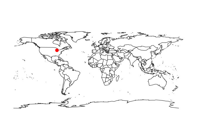
#>        Name                                            Location
#> 1 Gull Lake Kalamazoo / Barry counties, Michigan, United States
#>   Primary outflows Basin countries Surface area Max. depth Surface elevation
#> 1   Gull Creek [1]   United States            8         34               268
#>      Lat     Lon
#> 1 42.399 -85.411lake_wiki("Gull Lake (Michigan)", map = TRUE, database = "usa")
#> Retrieving data from: https://en.wikipedia.org/wiki/Gull_Lake_(Michigan)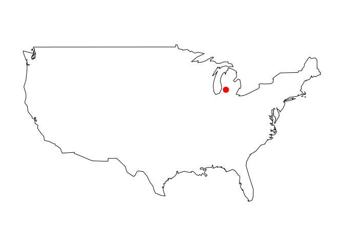
#>        Name                                            Location
#> 1 Gull Lake Kalamazoo / Barry counties, Michigan, United States
#>   Primary outflows Basin countries Surface area Max. depth Surface elevation
#> 1   Gull Creek [1]   United States            8         34               268
#>      Lat     Lon
#> 1 42.399 -85.411lake_wiki("Lake Nipigon", map = TRUE, regions = "Canada")
#> Retrieving data from: https://en.wikipedia.org/wiki/Lake_Nipigon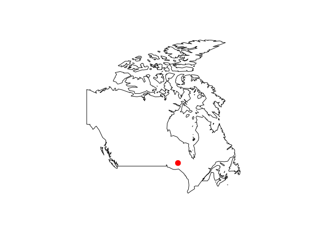
#>           Name Location Lake type Primary outflows Catchment area
#> 1 Lake Nipigon  Ontario   Glacial    Nipigon River          25400
#>   Basin countries Surface area Average depth Max. depth Water volume
#> 1          Canada         4848          54.9        165     2.48e+11
#>   Shore length1 Surface elevation   Lat   Lon
#> 1 1044 260 49.83 -88.5lake_wiki("Cass Lake (Michigan)", map = TRUE, database = "state", regions = "Michigan")
#> Retrieving data from: https://en.wikipedia.org/wiki/Cass_Lake_(Michigan)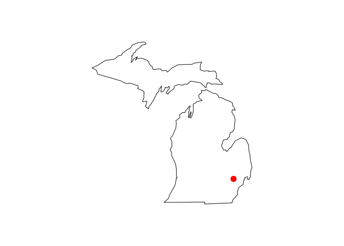
#>        Name                 Location Basin countries Surface area Max. depth
#> 1 Cass Lake Oakland County, Michigan   United States     5.179997         37
#>   Surface elevation    Lat     Lon
#> 1               283 42.606 -83.365
These binaries (installable software) and packages are in development.
They may not be fully stable and should be used with caution. We make no claims about them.
Health stats visible at Monitor.