
The hardware and bandwidth for this mirror is donated by dogado GmbH, the Webhosting and Full Service-Cloud Provider. Check out our Wordpress Tutorial.
If you wish to report a bug, or if you are interested in having us mirror your free-software or open-source project, please feel free to contact us at mirror[@]dogado.de.

![]()
![]()
![]()
Tidygeocoder makes getting data from geocoding services easy. A unified high-level interface is provided for a selection of supported geocoding services and results are returned in tibble (dataframe) format.
Note that you should exercise due diligence when geocoding sensitive data as tidygeocoder utilizes third party web services to perform geocoding. Refer to the documentation on your selected geocoding service for information on how your data will be utilized and stored. See further information on this subject here.
Features:
In addition to the usage examples below, see the Getting Started Vignette and blog posts on tidygeocoder.
To install the stable version from CRAN (the official R package servers):
install.packages('tidygeocoder')Alternatively, you can install the latest development version from GitHub:
devtools::install_github("jessecambon/tidygeocoder")In this first example we will geocode a few addresses using the
geocode() function and plot them on a map with ggplot.
library(dplyr, warn.conflicts = FALSE)
library(tidygeocoder)

# create a dataframe with addresses
some_addresses <- tibble::tribble(
~name,                  ~addr,
"White House",          "1600 Pennsylvania Ave NW, Washington, DC",
"Transamerica Pyramid", "600 Montgomery St, San Francisco, CA 94111",
"Willis Tower",         "233 S Wacker Dr, Chicago, IL 60606"
)

# geocode the addresses
lat_longs <- some_addresses %>%
  geocode(addr, method = 'osm', lat = latitude , long = longitude)
#> Passing 3 addresses to the Nominatim single address geocoder
#> Query completed in: 3 seconds
The geocode() function geocodes addresses contained in a
dataframe. The Nominatim (“osm”)
geocoding service is used here, but other services can be specified with
the method argument. Only latitude and longitude are
returned from the geocoding service in this example, but
full_results = TRUE can be used to return all of the data
from the geocoding service. See the geo() function
documentation for details.
| name | addr | latitude | longitude |
|---|---|---|---|
| White House | 1600 Pennsylvania Ave NW, Washington, DC | 38.89770 | -77.03655 |
| Transamerica Pyramid | 600 Montgomery St, San Francisco, CA 94111 | 37.79519 | -122.40279 |
| Willis Tower | 233 S Wacker Dr, Chicago, IL 60606 | 41.87874 | -87.63596 |
Now that we have the longitude and latitude coordinates, we can use ggplot to plot our addresses on a map.
library(ggplot2)

ggplot(lat_longs, aes(longitude, latitude), color = "grey99") +
  borders("state") + geom_point() +
  ggrepel::geom_label_repel(aes(label = name)) +
  theme_void()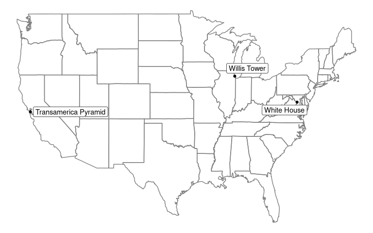
A map of the United States with the places of interest mentioned above plotted on top of it.
To perform reverse geocoding (obtaining addresses from geographic
coordinates), we can use the reverse_geocode() function.
The arguments are similar to the geocode() function, but
now we specify the input data columns with the lat and
long arguments. The input dataset used here is the results
of the geocoding query above.
The single line address is returned in a column named by the
address argument and all columns from the geocoding service
results are returned because full_results = TRUE. See the
reverse_geo() function documentation for more details.
reverse <- lat_longs %>%
  reverse_geocode(lat = latitude, long = longitude, method = 'osm',
                  address = address_found, full_results = TRUE) %>%
  select(-addr, -licence)
#> Passing 3 coordinates to the Nominatim single coordinate geocoder
#> Query completed in: 3 seconds
#> New names:
#> • `name` -> `name...1`
#> • `name` -> `name...17`| name…1 | latitude | longitude | address_found | place_id | osm_type | osm_id | osm_lat | osm_lon | class | type | place_rank | importance | addresstype | name…17 | office | house_number | road | borough | city | state | ISO3166-2-lvl4 | postcode | country | country_code | boundingbox | tourism | quarter | building | neighbourhood | suburb | county |
|---|---|---|---|---|---|---|---|---|---|---|---|---|---|---|---|---|---|---|---|---|---|---|---|---|---|---|---|---|---|---|---|
| White House | 38.89770 | -77.03655 | White House, 1600, Pennsylvania Avenue Northwest, Ward 2, Washington, District of Columbia, 20500, United States | 321631063 | way | 238241022 | 38.897699700000004 | -77.03655315 | office | government | 30 | 0.6863356 | office | White House | White House | 1600 | Pennsylvania Avenue Northwest | Ward 2 | Washington | District of Columbia | US-DC | 20500 | United States | us | 38.8974908 , 38.8979110 , -77.0368537, -77.0362519 | NA | NA | NA | NA | NA | NA |
| Transamerica Pyramid | 37.79519 | -122.40279 | Transamerica Pyramid, 600, Montgomery Street, Financial District, San Francisco, California, 94111, United States | 300093323 | way | 24222973 | 37.7951883 | -122.40279022107812 | tourism | attraction | 30 | 0.4485801 | tourism | Transamerica Pyramid | NA | 600 | Montgomery Street | NA | San Francisco | California | US-CA | 94111 | United States | us | 37.7948854 , 37.7954472 , -122.4031399, -122.4024317 | Transamerica Pyramid | Financial District | NA | NA | NA | NA |
| Willis Tower | 41.87874 | -87.63596 | Willis Tower, 233, South Wacker Drive, Printer’s Row, Loop, Chicago, Cook County, Illinois, 60606, United States | 344062520 | way | 380868216 | 41.878738049999995 | -87.63596121188081 | building | commercial | 30 | 0.5331678 | building | Willis Tower | NA | 233 | South Wacker Drive | NA | Chicago | Illinois | US-IL | 60606 | United States | us | 41.8781922 , 41.8792768 , -87.6365297, -87.6353939 | NA | NA | Willis Tower | Printer’s Row | Loop | Cook County |
For inspiration, here are a few articles (with code) that leverage tidygeocoder:
Contributions to the tidygeocoder package are welcome. File an issue for bug fixes or suggested features. If you would like to contribute code such as adding support for a new geocoding service, reference the developer notes for instructions and documentation.
Use the citation() function:
citation('tidygeocoder')To cite tidygeocoder use: Cambon J, Hernangómez D, Belanger C, Possenriede D (2021). tidygeocoder: An R package for geocoding. Journal of Open Source Software, 6(65), 3544, https://doi.org/10.21105/joss.03544 (R package version 1.0.6) A BibTeX entry for LaTeX users is @Article{, title = {tidygeocoder: An R package for geocoding}, author = {Jesse Cambon and Diego Hernangómez and Christopher Belanger and Daniel Possenriede}, year = {2021}, journal = {Journal of Open Source Software}, publisher = {The Open Journal}, doi = {10.21105/joss.03544}, url = {https://doi.org/10.21105/joss.03544}, volume = {6}, number = {65}, pages = {3544}, note = {R package version 1.0.6}, }
Or refer to the citation page.
These binaries (installable software) and packages are in development.
They may not be fully stable and should be used with caution. We make no claims about them.
Health stats visible at Monitor.