The hardware and bandwidth for this mirror is donated by dogado GmbH, the Webhosting and Full Service-Cloud Provider. Check out our Wordpress Tutorial.
If you wish to report a bug, or if you are interested in having us mirror your free-software or open-source project, please feel free to contact us at mirror[@]dogado.de.
![]()
![]()
tabularmapsは、CC0で公開されているカラム地図プロジェクトが進める行政区分等のグリッドレイアウトによる可視化をRパッケージとして提供するものです。
インストールはGitHubを経由して行います。まずremotesパッケージをCRANからインストールした後、remotes::install_github()で行ってください。
install.packages("remotes")
remotes::install_github("uribo/tabularmaps")library(tabularmaps)
library(ggplot2)日本国内
47都道府県
tabularmap(jpn77,
x,
y,
group = prefecture,
fill = region_kanji,
label = prefecture_kanji,
size = 3,
family = "IPAexGothic") +
theme_tabularmap(base_family = "IPAexGothic") +
scale_fill_jpregion(lang = "jp",
name = "八地方区分")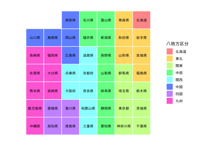 東京23区
東京23区
tabularmap(tky23,
           x,
           y,
           group = ward,
           fill = ward,
           label = ward_kanji,
           family = "IPAexGothic",
           .expand_size = 12.5) +
  theme_tabularmap(base_family = "IPAexGothic") +
  guides(fill = FALSE)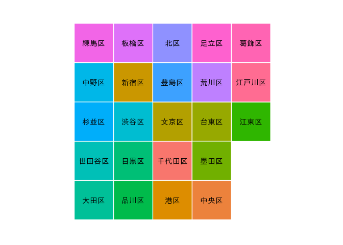
国際
ISO-3166による国名
tabularmap(iso3166,
           x,
           y,
           group = iso3c,
           fill = continent,
           label = iso3c,
           size = 2,
           .expand_size = 20,
           .radius_size = 10) +
  theme_tabularmap() +
  guides(fill = guide_legend(title = "Continent")) +
  theme(legend.title = element_text(size = 10),
        legend.text = element_text(size = 8))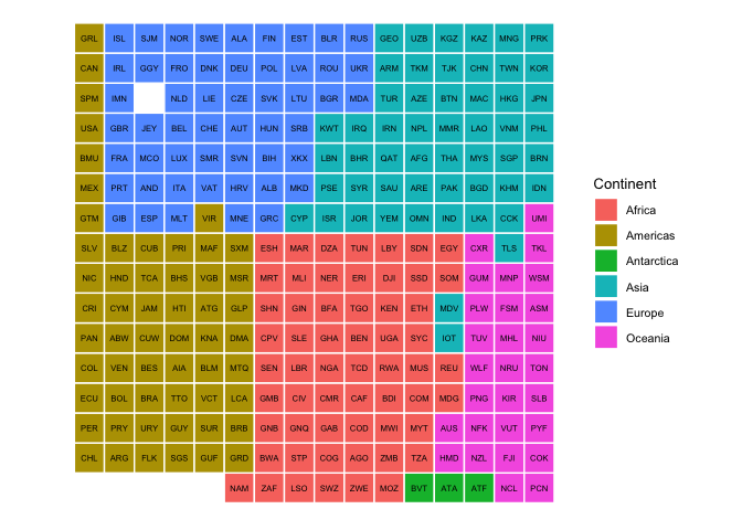
These binaries (installable software) and packages are in development.
They may not be fully stable and should be used with caution. We make no claims about them.
Health stats visible at Monitor.