
The hardware and bandwidth for this mirror is donated by dogado GmbH, the Webhosting and Full Service-Cloud Provider. Check out our Wordpress Tutorial.
If you wish to report a bug, or if you are interested in having us mirror your free-software or open-source project, please feel free to contact us at mirror[@]dogado.de.
![]()
![]()
The slopes R package calculates the slope (longitudinal steepness, also known as gradient) of roads, rivers and other linear (simple) features, based on two main inputs:
sf packageterra package
(SpatRaster)Data on slopes are useful in many fields of research, including hydrology,
natural hazards (including flooding and landslide
risk management), recreational and competitive sports such as cycling,
hiking, and skiing.
Slopes are also also important in some branches of transport and
emissions modelling and ecology. See the
intro-to-slopes
vignette for details on fields using slope data and the need for
this package.
This README covers installation and basic usage. For more information about slopes and how to use the package to calculate them, see the get started and the introduction to slopes vignette.
The package takes two main types of input data for slope calculation: - vector geographic objects representing linear features, and - elevation values from a DEM representing a continuous terrain surface or which can be downloaded using functionality in the package
The package can be used with two sources of elevation data: - openly
available elevation data via an interface to the ceramic package,
enabling estimation of hilliness for routes anywhere worldwide even when
local DEM data is lacking. The package takes geographic lines objects
and returns elevation data per vertex (providing the output as a 3D
point geometry in the sf package by default) and per line
feature (providing average gradient by default). - an elevation model,
available on your machine.
Install the released version of slopes from CRAN with:
install.packages("slopes")Install the development version from GitHub with:
# install.packages("remotes")
remotes::install_github("ropensci/slopes")If you do not already have DEM data and want to make use of the
package’s ability to download them using the ceramic
package, install the package with suggested dependencies, as
follows:
install.packages("slopes", dependencies = "Suggests")
# install.packages("remotes")
remotes::install_github("ropensci/slopes", dependencies = "Suggests")
Furthermore, you will need to add a MapBox API key to be able to get
DEM datasets, by signing up and registering for a key at
https://console.mapbox.com/account/access-tokens/ and then
following these steps:
usethis::edit_r_environ()
# Then add the following line to the file that opens:
MAPBOX_API_KEY=xxxxx # replace XXX with your api key# Check that the key is set
Sys.getenv("MAPBOX_API_KEY")Load the package in the usual way. We will also load the
sf library:
library(slopes)
library(sf)
The minimum input data requirement for using the package is an
sf object containing LINESTRING geometries, as illustrated
below (requires a MapBox API key):
sf_linestring = lisbon_route # import or load a linestring object# sf_linestring_xyz = elevation_add(sf_linestring) # dem = NULL
# #> Loading required namespace: ceramic
# #> Preparing to download: 12 tiles at zoom = 12 from
# #> https://api.mapbox.com/v4/mapbox.terrain-rgb/With the default argument dem = NULL, the function
downloads the necessary elevation information from Mapbox. You can also
this use a local DEM (dem = ...), as shown in the example
below:
sf_linestring_xyz_local = elevation_add(sf_linestring, dem = dem_lisbon())In both cases you can obtain the average gradient of the linestring
with slope_xyz() and plot the elevation profile with
plot_slope() as follows:
slope_xyz(sf_linestring_xyz_local)
#>          1
#> 0.07817098
plot_slope(sf_linestring_xyz_local)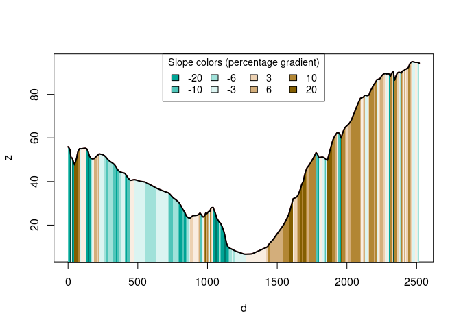
See more functions in Get started vignette.
Please note that this package is released with a Contributor Code of Conduct. By contributing to this project, you agree to abide by its terms.
These binaries (installable software) and packages are in development.
They may not be fully stable and should be used with caution. We make no claims about them.
Health stats visible at Monitor.