The hardware and bandwidth for this mirror is donated by dogado GmbH, the Webhosting and Full Service-Cloud Provider. Check out our Wordpress Tutorial.
If you wish to report a bug, or if you are interested in having us mirror your free-software or open-source project, please feel free to contact us at mirror[@]dogado.de.
![]()
A lightweight implementation of the geomorphon terrain form classification algorithm of Jasiewicz and Stepinski (2013) doi:10.1016/j.geomorph.2012.11.005 based largely on the ‘GRASS GIS’ ‘r.geomorphon’ module.
This implementation employs a novel algorithm written in C++ and ‘RcppParallel’.
For the sake of simplicity, some GRASS-specific implementation
details have not been added. See ?geomorphons for
details.
You can install {rgeomorphon} from CRAN:
install.packages("rgeomorphon")And you can install the development version from GitHub:
# install.packages("remotes")
remotes::install_github("brownag/rgeomorphon")This is a basic example using the classic R volcano
dataset and {terra} SpatRaster object as input.
volcano is a 10m by 10m grid of elevation values from
Maunga Whau in the Auckland volcanic field of New Zealand.
library(terra)
#> terra 1.8.56
library(rgeomorphon)

# PARAMETERS
SEARCH = 7       # outer search radius (cells)
SKIP = 0         # inner skip radius (cells)
FLAT = 1         # flat angle threshold (degrees)

# classic volcano elevation data
data("volcano", package = "datasets")

# construct and georeference a SpatRaster object
dem <- terra::rast(volcano)
terra::crs(dem) <- terra::crs("EPSG:2193")
terra::ext(dem) <- c(1756968, 1757578, 5917000, 5917870)
names(dem) <- "Elevation (meters)"

# calculate geomorphons "forms"
system.time({
    rg <- geomorphons(
        dem,
        search = SEARCH,
        skip = SKIP,
        flat = FLAT
    )
})
#>    user  system elapsed
#>   0.058   0.005   0.050

# inspect result
plot(c(dem, rg),
     plg = list(x = "bottomleft",
                bty = "o",
                bg = "white"))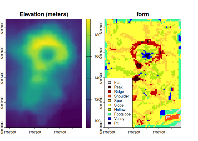
Now we will do a bathymetry example using the built in Salton Sea
dataset (salton).
See help("salton") for details.
library(terra)
library(rgeomorphon)

# PARAMETERS
SEARCH = 10      # outer search radius (cells)
SKIP = 3         # inner skip radius (cells)
FLAT = 0.1       # flat angle threshold (degrees)

# salton sea bathymetry sample data
data("salton", package = "rgeomorphon")

# construct and georeference a SpatRaster object
dem <- terra::rast(salton)
terra::crs(dem) <- attr(salton, "crs")
terra::ext(dem) <- attr(salton, "extent")
names(dem) <- "Elevation (feet)"

# calculate bathymorphons using 6-form system
system.time({
    rg <- geomorphons(
        dem,
        search = SEARCH,
        skip = SKIP,
        flat = FLAT,
        forms = "forms6"
    )
})
#>    user  system elapsed
#>   0.097   0.002   0.079

# inspect result
plot(c(dem, rg),
     plg = list(x = "bottomleft",
                bty = "o",
                bg = "white",
                cex = 0.85))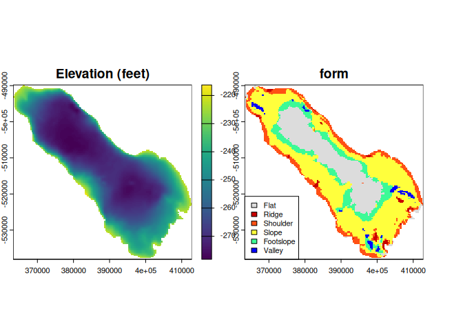
citation("rgeomorphon")
#> To cite package 'rgeomorphon' in publications use:
#>
#>   Brown A (2025). _rgeomorphon: A Lightweight Implementation of the
#>   'Geomorphon' Algorithm_. R package version 0.3.0,
#>   <https://github.com/brownag/rgeomorphon/>.
#>
#>   Jasiewicz J, Stepinski T (2013). "Geomorphons - a pattern recognition
#>   approach to classification and mapping of landforms."
#>   _Geomorphology_, *182*, 147-156. doi:10.1016/j.geomorph.2012.11.005
#>   <https://doi.org/10.1016/j.geomorph.2012.11.005>.
#>
#>   Jasiewicz J, Stepinski T, GRASS Development Team (2024). _Geographic
#>   Resources Analysis Support System (GRASS) Software, Version 8.3_.
#>   Open Source Geospatial Foundation, USA. r.geomorphon module,
#>   <https://grass.osgeo.org/grass-stable/manuals/r.geomorphon.html>.
#>
#> To see these entries in BibTeX format, use 'print(<citation>,
#> bibtex=TRUE)', 'toBibtex(.)', or set
#> 'options(citation.bibtex.max=999)'.
These binaries (installable software) and packages are in development.
They may not be fully stable and should be used with caution. We make no claims about them.
Health stats visible at Monitor.