The hardware and bandwidth for this mirror is donated by dogado GmbH, the Webhosting and Full Service-Cloud Provider. Check out our Wordpress Tutorial.
If you wish to report a bug, or if you are interested in having us mirror your free-software or open-source project, please feel free to contact us at mirror[@]dogado.de.
![]()
![]()
![]()
Tools for querying, downloading, and networking both the National Hydrography Dataset (NHD) and NHDPlus datasets.
CRAN policy is that no package can write to a persistent location by
default. As a result, nhdR writes all data to a temporary
location unless a temporary = FALSE argument is passed to
the nhd_plus_get/nhd_get functions.
Alternatively, nhdR will automatically write data to a
persistent location if the nhdR_path environment variable
is set. To do this, add the following line to your
.Rprofile:
Sys.setenv(nhdR_path = file.path(rappdirs::user_data_dir(appname = "nhdR",
      appauthor = "nhdR")))
Your .Rprofile file can be edited using the
usethis::edit_r_profile() function.
install.packages("nhdR")# install.packages("devtools")
devtools::install_github("jsta/nhdR")This package also requires an installation of 7-zip that can be called via the
command line using 7z or 7za.exe (check if
your machine is good to go with nhdR:::has_7z()).
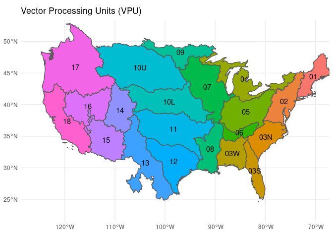
library(nhdR)NHD-Plus exports are organized by vector processing unit (vpu). See
below for a low resolution vpu map (also nhdR::vpu_shp). A
hi-res version can be found here.
# get a vpu export
nhd_plus_get(vpu = 4, "NHDSnapshot")
nhd_plus_get(vpu = 4, "NHDPlusAttributes")
nhd_plus_get(vpu = 4, "NHDPlusCatchment")
# list layers
nhd_plus_list(vpu = 4, "NHDSnapshot")
#> [1] "NHDArea.dbf" "NHDAreaEventFC.dbf"
#> [3] "NHDAreaEventFC.shp" "NHDArea.shp"
#> [5] "NHDFCode.dbf" "NHDFlowline.dbf"
#> [7] "NHDFlowline.shp" "NHDFlowline.shp.xml"
#> [9] "NHDLine.dbf" "NHDLineEventFC.dbf"
#> [11] "NHDLineEventFC.shp" "NHDLine.shp"
#> [13] "NHDPoint.dbf" "NHDPointEventFC.dbf"
#> [15] "NHDPointEventFC.shp" "NHDPoint.shp"
#> [17] "NHDReachCode_Comid.dbf" "NHDReachCrossReference.dbf"
#> [19] "NHDWaterbody.dbf" "NHDWaterbody.shp"
nhd_plus_list(vpu = 4, "NHDPlusAttributes")
#> [1] "CumulativeArea.dbf" "DivFracMP.dbf"
#> [3] "elevslope.dbf" "HeadwaterNodeArea.dbf"
#> [5] "MegaDiv.dbf" "PlusARPointEvent.dbf"
#> [7] "PlusFlowAR.dbf" "PlusFlow.dbf"
#> [9] "PlusFlowlineLakeMorphology.dbf" "PlusFlowlineVAA.dbf"
#> [11] "PlusWaterbodyLakeMorphology.dbf"
nhd_plus_list(vpu = 4, "NHDPlusCatchment")
#> [1] "Catchment.dbf" "Catchment.shp" "featureidgridcode.dbf"# get layer info
nhd_plus_info(vpu = 4, "NHDSnapshot", "NHDWaterbody")#> [1] "Driver: ESRI Shapefile; number of rows: 31830 "
#> [2] "Feature type: wkbPolygon with 3 dimensions"
#> [3] "Extent: (-93.24332 40.43575) - (-73.61814 48.11344)"
#> [4] "CRS: +proj=longlat +datum=NAD83 +no_defs "
#> [5] "LDID: 87 "
#> [6] "Number of fields: 12 "
#> [7] " name type length typeName"
#> [8] "1 COMID 0 9 Integer"
#> [9] "2 FDATE 9 10 Date"
#> [10] "3 RESOLUTION 4 7 String"
#> [11] "4 GNIS_ID 4 10 String"
#> [12] "5 GNIS_NAME 4 65 String"
#> [13] "6 AREASQKM 2 19 Real"
#> [14] "7 ELEVATION 2 19 Real"
#> [15] "8 REACHCODE 4 14 String"
#> [16] "9 FTYPE 4 24 String"
#> [17] "10 FCODE 0 9 Integer"
#> [18] "11 SHAPE_LENG 2 19 Real"
#> [19] "12 SHAPE_AREA 2 19 Real"# load layer
dt <- nhd_plus_load(vpu = 4, "NHDSnapshot", "NHDWaterbody")
#> Reading layer `NHDWaterbody' from data source
#> `/home/jemma/.local/share/nhdR/NHDPlus/GL_04_NHDSnapshot/NHDWaterbody.shp'
#> using driver `ESRI Shapefile'
#> Simple feature collection with 31830 features and 12 fields
#> Geometry type: POLYGON
#> Dimension: XYZ
#> Bounding box: xmin: -93.24332 ymin: 40.43575 xmax: -73.61814 ymax: 48.11344
#> z_range: zmin: 0 zmax: 0
#> Geodetic CRS: NAD83NHD exports are organized by US state.
nhd_get(state = c("DC", "HI"))nhd_list(state = "DC")
#> [1] "ExternalCrosswalk" "NHDFCode"
#> [3] "NHDFeatureToMetadata" "NHDFlow"
#> [5] "NHDFlowlineVAA" "NHDMetadata"
#> [7] "NHDProcessingParameters" "NHDReachCodeMaintenance"
#> [9] "NHDReachCrossReference" "NHDSourceCitation"
#> [11] "NHDStatus" "NHDVerticalRelationship"
#> [13] "NHDPoint" "NHDFlowline"
#> [15] "NHDLine" "NHDArea"
#> [17] "NHDWaterbody" "NHDAreaEventFC"
#> [19] "NHDLineEventFC" "NHDPointEventFC"
#> [21] "WBDLine" "NonContributingDrainageArea"
#> [23] "NWISBoundary" "NWISDrainageArea"
#> [25] "WBDHU14" "WBDHU8"
#> [27] "WBDHU2" "WBDHU4"
#> [29] "WBDHU6" "WBDHU10"
#> [31] "WBDHU12" "WBDHU16"
#> [33] "HYDRO_NET_Junctions"
#> attr(,"driver")
#> [1] "OpenFileGDB"
#> attr(,"nlayers")
#> [1] 33nhd_info(state = "DC", dsn = "NHDWaterbody")
#> Source: "/home/jemma/.local/share/nhdR/NHD_H_District_of_Columbia_State_GDB.gdb", layer: "NHDWaterbody"
#> Driver: OpenFileGDB; number of rows: 8011
#> Feature type: wkbPolygon with 3 dimensions
#> Extent: (-78.07095 38.52142) - (-76.82219 39.64683)
#> CRS: +proj=longlat +datum=NAD83 +no_defs
#> Number of fields: 13
#> name type length typeName
#> 1 Permanent_Identifier 4 40 String
#> 2 FDate 11 0 DateTime
#> 3 Resolution 0 0 Integer
#> 4 GNIS_ID 4 10 String
#> 5 GNIS_Name 4 65 String
#> 6 AreaSqKm 2 0 Real
#> 7 Elevation 2 0 Real
#> 8 ReachCode 4 14 String
#> 9 FType 0 0 Integer
#> 10 FCode 0 0 Integer
#> 11 VisibilityFilter 0 0 Integer
#> 12 Shape_Length 2 0 Real
#> 13 Shape_Area 2 0 Realhead(nhd_load(state = "DC", dsn = "NHDWaterbody"))
#> Reading layer `NHDWaterbody' from data source
#> `/home/jemma/.local/share/nhdR/NHD_H_District_of_Columbia_State_GDB.gdb'
#> using driver `OpenFileGDB'
#> Simple feature collection with 8011 features and 13 fields
#> Geometry type: MULTIPOLYGON
#> Dimension: XYZ
#> Bounding box: xmin: -78.07095 ymin: 38.52142 xmax: -76.82219 ymax: 39.64683
#> z_range: zmin: 0 zmax: 0
#> Geodetic CRS: NAD83
#> Reading query `SELECT * from NHDWaterbody LIMIT 1' from data source `/home/jemma/.local/share/nhdR/NHD_H_District_of_Columbia_State_GDB.gdb'
#> using driver `OpenFileGDB'
#> Simple feature collection with 1 feature and 13 fields
#> Geometry type: MULTIPOLYGON
#> Dimension: XYZ
#> Bounding box: xmin: -76.99652 ymin: 38.68957 xmax: -76.99631 ymax: 38.6897
#> z_range: zmin: 0 zmax: 0
#> Geodetic CRS: NAD83
#> Simple feature collection with 6 features and 13 fields
#> Geometry type: POLYGON
#> Dimension: XY
#> Bounding box: xmin: -77.5767 ymin: 38.68957 xmax: -76.99631 ymax: 39.5882
#> Geodetic CRS: WGS 84
#> Permanent_Identifier FDate Resolution GNIS_ID GNIS_Name
#> 1 46565431 2002-07-21 18:00:00 2 <NA> <NA>
#> 2 51767181 2002-08-14 18:00:00 2 <NA> <NA>
#> 3 51767223 2002-08-14 18:00:00 2 <NA> <NA>
#> 4 51767287 2002-08-14 18:00:00 2 <NA> <NA>
#> 5 51767709 2002-08-14 18:00:00 2 <NA> <NA>
#> 6 51768273 2002-08-14 18:00:00 2 <NA> <NA>
#> AreaSqKm Elevation ReachCode FType FCode VisibilityFilter Shape_Length
#> 1 0.000 NA 02070010004605 436 43624 0 0.0005402029
#> 2 0.002 NA 02070008004808 390 39004 50000 0.0017289109
#> 3 0.001 NA 02070008004829 390 39004 2000000 0.0013369633
#> 4 0.001 NA 02070008004860 390 39004 24000 0.0011083831
#> 5 0.002 NA 02070008005063 390 39004 50000 0.0016429957
#> 6 0.001 NA 02070008005335 390 39004 24000 0.0012442057
#> Shape_Area Shape
#> 1 1.879174e-08 POLYGON ((-76.99631 38.6896...
#> 2 1.954519e-07 POLYGON ((-77.56946 39.5881...
#> 3 1.239613e-07 POLYGON ((-77.56954 39.5567...
#> 4 8.130533e-08 POLYGON ((-77.57658 39.5250...
#> 5 1.745505e-07 POLYGON ((-77.46919 39.3298...
#> 6 8.126193e-08 POLYGON ((-77.2087 39.18799...These binaries (installable software) and packages are in development.
They may not be fully stable and should be used with caution. We make no claims about them.
Health stats visible at Monitor.