
The hardware and bandwidth for this mirror is donated by dogado GmbH, the Webhosting and Full Service-Cloud Provider. Check out our Wordpress Tutorial.
If you wish to report a bug, or if you are interested in having us mirror your free-software or open-source project, please feel free to contact us at mirror[@]dogado.de.




[!IMPORTANT]
Attribution is required when sharing geoBoundaries boundaries or derived products.
The geobounds package provides an R-friendly interface for downloading administrative boundaries from geoBoundaries, the Global Database of Political Administrative Boundaries. With geobounds, you can:
In short, if you work with administrative boundaries in R, geobounds simplifies downloading, cache management and integration with spatial data workflows.
Install geobounds from CRAN:
install.packages("geobounds")Check the documentation for the development version at https://dieghernan.github.io/geobounds/dev/
You can install the development version of geobounds with:
# install.packages("pak")
pak::pak("dieghernan/geobounds")
Alternatively, you can install geobounds from r-universe:
# Install geobounds.
install.packages(
  "geobounds",
  repos = c(
    "https://dieghernan.r-universe.dev",
    "https://cloud.r-project.org"
  )
)library(geobounds)
sri_lanka_adm1 <- gb_get_adm1("Sri Lanka")
sri_lanka_adm2 <- gb_get_adm2("Sri Lanka")
sri_lanka_adm3 <- gb_get_adm3("Sri Lanka")
library(sf)
library(dplyr)
library(ggplot2)
ggplot(sri_lanka_adm3) +
geom_sf(fill = "#DFDFDF", color = "white") +
geom_sf(data = sri_lanka_adm2, fill = NA, color = "#F0B323") +
geom_sf(data = sri_lanka_adm1, fill = NA, color = "black") +
labs(
caption = paste(
"Sources: geoBoundaries, OpenStreetMap and Wambacher,",
"license: ODbL 1.0"
)
) +
theme_void()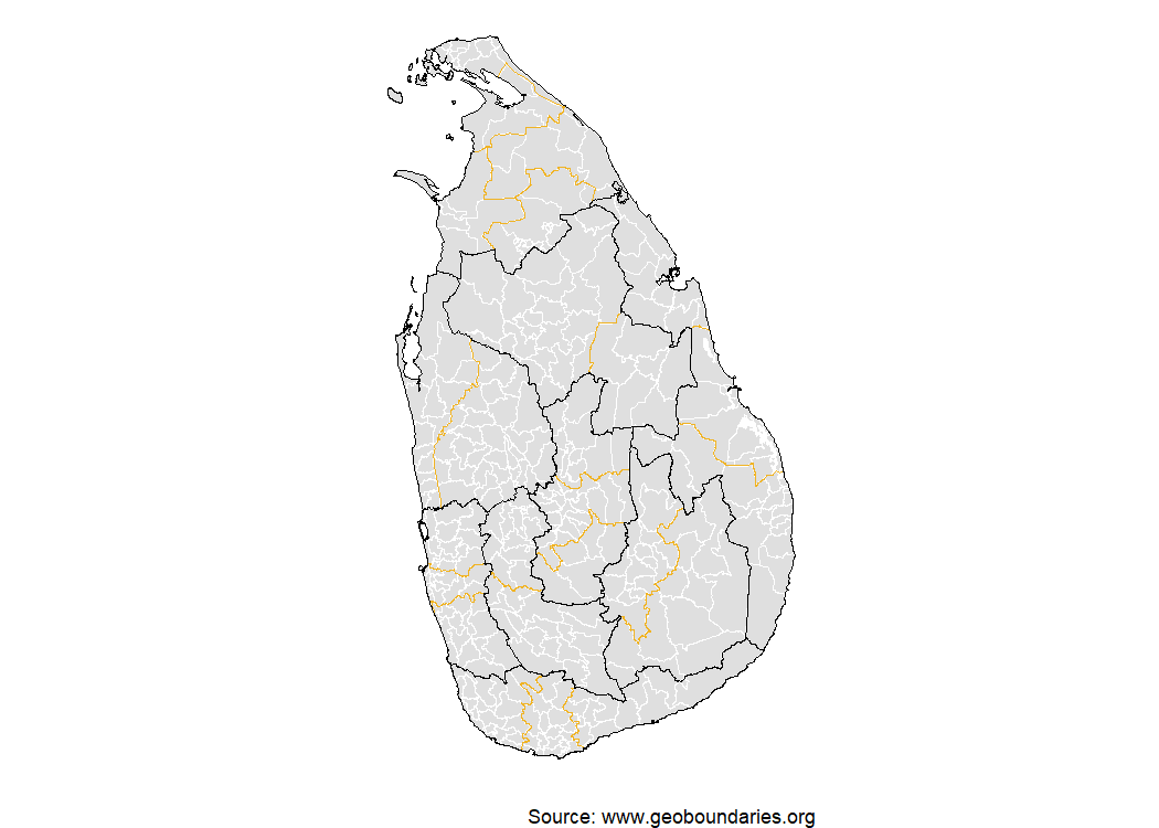
geoBoundaries provides three release types with different data sources, validation processes and licensing terms:
Use the release_type argument to request a specific
release type, for example,
gb_get_adm1("Sri Lanka", release_type = "gbHumanitarian").
For coverage and boundary metadata by release type, see the geobounds articles.
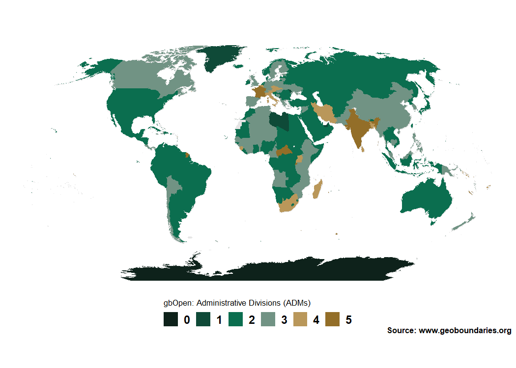
Map the highest available ADM level in geoBoundaries by country:
library(geobounds)
library(ggplot2)
library(dplyr)

world <- gb_get_world()
max_lvl <- gb_get_max_adm_lvl(release_type = "gbOpen")

world_max <- world |>
  mutate(boundaryISO = shapeGroup) |>
  left_join(max_lvl) |>
  mutate(max_lvl = factor(maxBoundaryType, levels = 0:5))

pal <- c("#0e221b", "#0f4a38", "#0b6e4f", "#719384", "#b9975a", "#936e28")
names(pal) <- levels(world_max$max_lvl)

ggplot(world_max) +
  geom_sf(fill = "#e5e5e5", color = "#e5e5e5") +
  geom_sf(aes(fill = max_lvl), color = "transparent") +
  scale_fill_manual(values = pal, na.translate = FALSE, drop = FALSE) +
  guides(fill = guide_legend(direction = "horizontal", nrow = 1)) +
  coord_sf(expand = TRUE, crs = "+proj=robin") +
  theme_void() +
  theme(
    plot.background = element_rect(fill = "white", color = NA),
    text = element_text(family = "sans", face = "bold"),
    legend.position = "bottom",
    legend.title.position = "top",
    legend.title = element_text(size = rel(0.75), face = "plain"),
    legend.text = element_text(size = rel(1)),
    legend.text.position = "right",
    legend.key.height = unit(1, "line"),
    legend.key.width = unit(1, "line"),
    plot.caption = element_text(
      size = rel(0.7),
      margin = margin(r = 4)
    )
  ) +
  labs(
    fill = "gbOpen: Highest available ADM level",
    caption = "Source: geoBoundaries (CGAZ and gbOpen metadata)"
  )
The geobounds software is released under the MIT license. This license does not cover boundaries downloaded through the package or figures derived from those boundaries.
Each boundary retains the original license reported by
geoBoundaries. Before reusing or redistributing
boundaries, use gb_get_metadata() to check
boundaryLicense, licenseDetail,
licenseSource, boundarySource and
boundarySourceURL. Always acknowledge
geoBoundaries. Consult these fields for any additional
source attribution, license link, share-alike notice or modification
statement required by the boundary’s license.
gbAuthoritative contains UN SALB boundaries restricted
to non-commercial use.
Hernangómez D (2026). geobounds: Download Administrative Boundary Data from geoBoundaries. doi:10.32614/CRAN.package.geobounds. https://dieghernan.github.io/geobounds/.
A BibTeX entry for LaTeX users:
@Manual{R-geobounds,
  title = {{geobounds}: Download Administrative Boundary Data from geoBoundaries},
  author = {Diego Hernangómez},
  year = {2026},
  version = {1.0.1},
  url = {https://dieghernan.github.io/geobounds/},
  abstract = {Provides tools to download individual country boundaries and global composite boundaries from geoBoundaries <https://www.geoboundaries.org/> across multiple administrative (ADM) levels. Returns boundaries as sf objects for mapping and spatial analysis. Runfola et al. (2020) <doi:10.1371/journal.pone.0231866> describe the underlying database.},
  doi = {10.32614/CRAN.package.geobounds},
}These binaries (installable software) and packages are in development.
They may not be fully stable and should be used with caution. We make no claims about them.
Health stats visible at Monitor.