The hardware and bandwidth for this mirror is donated by dogado GmbH, the Webhosting and Full Service-Cloud Provider. Check out our Wordpress Tutorial.
If you wish to report a bug, or if you are interested in having us mirror your free-software or open-source project, please feel free to contact us at mirror[@]dogado.de.
(Sorry, English version of README is not availavle for now.)
![]()

![]()
このパッケージは、国土地理院 基盤地図情報 (FGD: Fundermental Geographic Data https://fgd.gsi.go.jp/download/menu.php) からダウンロードしたデータ(バージョン4.1に対応)をR上で扱うためにデータの変換を行う関数を提供します。
パッケージのインストールは、CRANから行います。
install.packages("fgdr")開発版を利用する場合はGitHub経由でインストールします。
install.packages("remotes")
remotes::install_github("uribo/fgdr")fgdrパッケージを使った、基盤地図情報データの読み込み方法を紹介します。
なお、fgdrパッケージでは、基盤地図情報のデータをダウンロードする関数は用意していません。読み込むデータは各自でダウンロードしてください。また、読み込んだデータの扱いについても基盤地図情報ダウンロードサービスの利用規約に従ってください。
このパッケージには、基盤地図情報データダウロードサービスが提供している
について、データフレーム、Rの地理空間データを扱うためのクラスであるsfまたはraster、stars、terraとして返却する関数が備わっています。
library(fgdr)
library(terra)
library(sf)基本項目のデータはread_fgd()で読み込みます。この関数は対象のファイルの種類に応じて、自動的に地物の種類を判別して返却します。例えば、行政区画代表点
(AdmPt) では下記のようにポイントデータです。
read_fgd("FG-GML-523346-AdmPt-20180701-0001.xml")#> Simple feature collection with 4 features and 8 fields
#> Geometry type: POINT
#> Dimension: XY
#> Bounding box: xmin: 133.7835 ymin: 35.00697 xmax: 133.8736 ymax: 35.06013
#> Geodetic CRS: JGD2011
#> # A tibble: 4 × 9
#> gml_id type name adm_code life_span_from development_date org_gi_level
#> <chr> <chr> <chr> <chr> <date> <date> <int>
#> 1 K6_48162126… 郡市… 真庭… 33214 2015-05-25 2018-07-03 25000
#> 2 K6_48180126… 町村… 美咲… 33666 2015-05-25 2018-07-03 25000
#> 3 K6_48183126… 郡市… 津山… 33203 2015-05-25 2018-07-03 25000
#> 4 K6_48192126… 郡市… 津山… 33203 2015-05-25 2018-07-03 25000
#> # … with 2 more variables: visibility <chr>, geometry <POINT [°]>水域 (WL) はライン、行政区画 (AdmArea) はポリゴンデータになります。
read_fgd("FG-GML-523346-AdmArea-20180701-0001.xml")#> Simple feature collection with 4 features and 8 fields
#> Geometry type: POLYGON
#> Dimension: XY
#> Bounding box: xmin: 133.75 ymin: 35 xmax: 133.875 ymax: 35.08333
#> Geodetic CRS: JGD2011
#> # A tibble: 4 × 9
#> gml_id type name adm_code life_span_from development_date org_gi_level
#> <chr> <chr> <chr> <chr> <date> <date> <int>
#> 1 K4_523346_1… 町村… 美咲… 33666 2018-07-02 2018-07-03 25000
#> 2 K4_523346_2… 郡市… 真庭… 33214 2018-07-02 2018-07-03 25000
#> 3 K4_523346_3… 郡市… 津山… 33203 2018-07-02 2018-07-03 25000
#> 4 K4_523346_4… 郡市… 津山… 33203 2018-07-02 2018-07-03 25000
#> # … with 2 more variables: visibility <chr>, geometry <POLYGON [°]>標高のメッシュデータである数値標高モデル(DEM)
のデータはデータフレームまたはrasterとして読み込みます。対象のファイルが保存されているパスおよび数値標高データの種類を指定したread_fgd_dem()実行します。
read_fgd_dem("FG-GML-5135-63-00-DEM5A-20161001.xml",
             resolution = 5,
             return_class = "data.table")
#> type value
#> 1: データなし NA [m]
#> 2: データなし NA [m]
#> 3: データなし NA [m]
#> 4: データなし NA [m]
#> 5: データなし NA [m]
#> ---
#> 33746: 内水面 -9999 [m]
#> 33747: 内水面 -9999 [m]
#> 33748: 内水面 -9999 [m]
#> 33749: 内水面 -9999 [m]
#> 33750: 内水面 -9999 [m]デフォルトでは返り値のオブジェクトがデータフレームですが、これは引数return_class =によりrasterやstars、terraのいずれかを選ぶことも可能です。terraとして読み込み、可視化する例を示します。
r <-
  read_fgd_dem("FG-GML-5135-63-00-DEM5A-20161001.xml",
             resolution = 5,
return_class = "terra")par(family = "IPAexGothic")
plot(r)
title(main = "数値標高モデル (5mメッシュ): 51356300",
sub = "「基盤地図情報 数値標高モデル 5mメッシュ」(国土地理院)(https://fgd.gsi.go.jp/download/menu.php)\nをもとに瓜生真也(@uribo)が作成",
cex.main = 1,
cex.sub = 0.45,
adj = 1)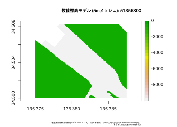
同様に10mメッシュのデータを読み込むにはresolution =を10に変更してください。
read_fgd_dem("FG-GML-5440-10-dem10b-20161001.xml",
             resolution = 10,
             return_class = "raster")
#> class : RasterLayer
#> dimensions : 750, 1125, 843750 (nrow, ncol, ncell)
#> resolution : 0.0001111111, 0.00011112 (x, y)
#> extent : 140, 140.125, 36.08333, 36.16667 (xmin, xmax, ymin, ymax)
#> crs : +proj=longlat +ellps=GRS80 +no_defs
#> source : memory
#> names : layer
#> values : 5, 316 (min, max)MIT
These binaries (installable software) and packages are in development.
They may not be fully stable and should be used with caution. We make no claims about them.
Health stats visible at Monitor.