The hardware and bandwidth for this mirror is donated by dogado GmbH, the Webhosting and Full Service-Cloud Provider. Check out our Wordpress Tutorial.
If you wish to report a bug, or if you are interested in having us mirror your free-software or open-source project, please feel free to contact us at mirror[@]dogado.de.
![]()
![]()
The goal of cyclestreets is to provide a simple R interface to the CycleStreets routing service.
It was split-out from stplanr for modularity.
You can install the released version of cyclestreets from CRAN with:
install.packages("cyclestreets")Install the development version with devtools as follows:
# install.packages("devtools")
devtools::install_github("cyclestreets/cyclestreets-r")A common need is to get from A to B:
library ("cyclestreets")
# stplanr::geo_code ("leeds rail station")
from = c(-1.544, 53.794)
# stplanr::geo_code ("leeds university")
to = c(-1.551, 53.807)
r = cyclestreets::journey(from, to, "balanced")
sf:::plot.sf(r)
#> Warning: plotting the first 10 out of 43 attributes; use max.plot = 43 to plot
#> all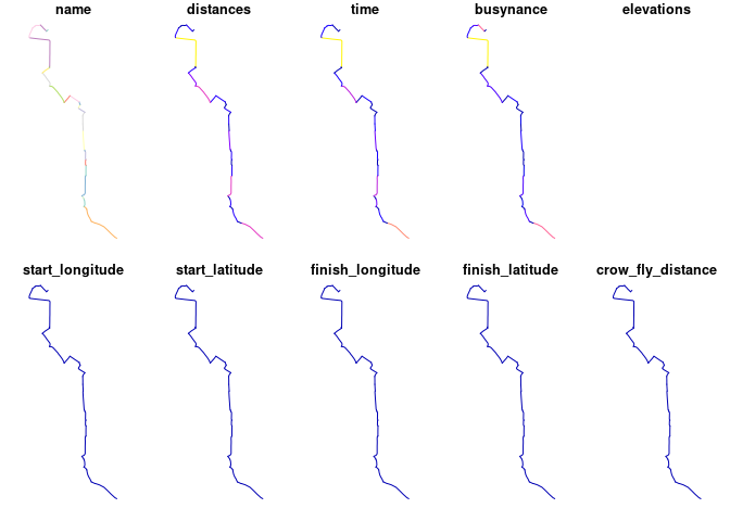
To get a key go to https://www.cyclestreets.net/api/apply/
Save the key as an environment varible using
export CYCLESTREETS=your_key_here by adding
CYCLESTREETS=your_key_here as a new line in your
.Renviron file, e.g. with the following command:
usethis::edit_r_environ()Check the map is good with leaflet:
library(leaflet)
p = colorNumeric("RdYlBu", domain = r$quietness, reverse = TRUE)
leaflet(r) %>%
  addTiles() %>%
  addPolylines(color = ~p(quietness), weight = 20, opacity = 0.9) %>%
  addLegend(pal = p, values = ~quietness)
Or tmap, highlighting the recently added ‘quietness’ variable:
library(tmap)
tmap_mode("view")
tm_shape(r) + tm_lines("quietness", palette = "RdYlBu", lwd = 3)
#> The legacy packages maptools, rgdal, and rgeos, underpinning the sp package,
#> which was just loaded, will retire in October 2023.
#> Please refer to R-spatial evolution reports for details, especially
#> https://r-spatial.org/r/2023/05/15/evolution4.html.
#> It may be desirable to make the sf package available;
#> package maintainers should consider adding sf to Suggests:.
#> The sp package is now running under evolution status 2
#> (status 2 uses the sf package in place of rgdal)
#> Breaking News: tmap 3.x is retiring. Please test v4, e.g. with
#> remotes::install_github('r-tmap/tmap')
#> tmap mode set to interactive viewing
#> Interactive map saved to /home/robin/github/cyclestreets/cyclestreets-r/m.html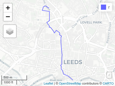
See an interactive version of this map, showing all variables per segment, here.
Or mapview:
mapview::mapview(r)Route types available are: fastest, quietest, balanced. See help
pages such as ?journey and https://www.cyclestreets.net/api/ for details.
You can also get streets by LTN status.
network_ltns = ltns(r)
plot(network_ltns)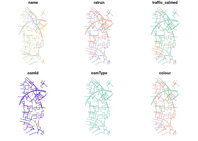
These binaries (installable software) and packages are in development.
They may not be fully stable and should be used with caution. We make no claims about them.
Health stats visible at Monitor.