The hardware and bandwidth for this mirror is donated by dogado GmbH, the Webhosting and Full Service-Cloud Provider. Check out our Wordpress Tutorial.
If you wish to report a bug, or if you are interested in having us mirror your free-software or open-source project, please feel free to contact us at mirror[@]dogado.de.
![]()
tigris is an R package that allows users to directly download and use TIGER/Line shapefiles (https://www.census.gov/geographies/mapping-files/time-series/geo/tiger-line-file.html) from the US Census Bureau.
To install the package from CRAN, issue the following command in R:
install.packages('tigris')Or, get the development version from GitHub:
devtools::install_github('walkerke/tigris')tigris functions return simple features objects with a default year of 2024. To get started, choose a function from the table below and use it with a state and/or county if required. You’ll get back an sf object for use in your mapping and spatial analysis projects:
library(tigris)
library(ggplot2)

manhattan_roads <- roads("NY", "New York")

ggplot(manhattan_roads) +
  geom_sf() +
  theme_void()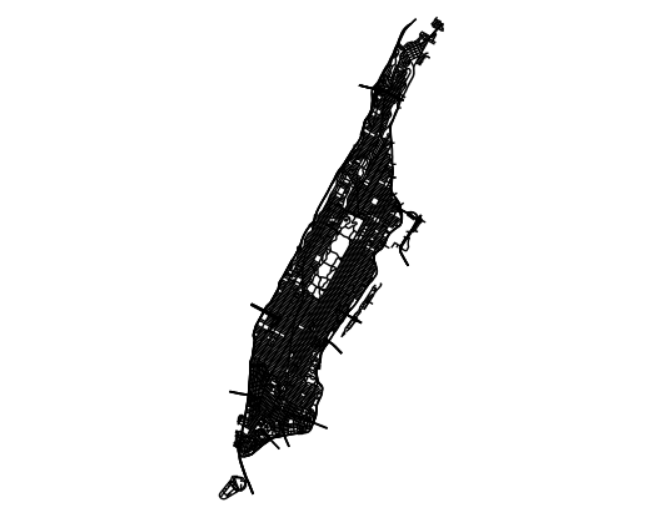
tigris only returns feature geometries for US Census data which default to the coordinate reference system NAD 1983 (EPSG: 4269). For US Census demographic data (optionally pre-joined to tigris geometries), try the tidycensus package. For help deciding on an appropriate coordinate reference system for your project, take a look at the crsuggest package.
To learn more about how to use tigris, read Chapter 5 of the book Analyzing US Census Data: Methods, Maps, and Models in R.
Python users may also be interested in pygris, a Python port of the tigris package.
Available datasets:
Please note: cartographic boundary files in tigris are not available for 2011 and 2012.
| Function | Datasets available | Years available |
|---|---|---|
nation() |
cartographic (1:5m; 1:20m) | 2013-2024 |
divisions() |
cartographic (1:500k; 1:5m; 1:20m) | 2013-2024 |
regions() |
cartographic (1:500k; 1:5m; 1:20m) | 2013-2024 |
states() |
TIGER/Line; cartographic (1:500k; 1:5m; 1:20m) | 1990, 2000, 2010-2024 |
counties() |
TIGER/Line; cartographic (1:500k; 1:5m; 1:20m) | 1990, 2000, 2010-2024 |
tracts() |
TIGER/Line; cartographic (1:500k) | 1990, 2000, 2010-2024 |
block_groups() |
TIGER/Line; cartographic (1:500k) | 1990, 2000, 2010-2024 |
blocks() |
TIGER/Line | 2000, 2010-2024 |
places() |
TIGER/Line; cartographic (1:500k) | 2011-2024 |
pumas() |
TIGER/Line; cartographic (1:500k) | 2012-2024 |
school_districts() |
TIGER/Line; cartographic | 2011-2024 |
zctas() |
TIGER/Line; cartographic (1:500k) | 2000, 2010, 2012-2024 |
congressional_districts() |
TIGER/Line; cartographic (1:500k; 1:5m; 1:20m) | 2011-2024 |
state_legislative_districts() |
TIGER/Line; cartographic (1:500k) | 2011-2024 |
voting_districts() |
TIGER/Line | 2012, 2020 |
area_water() |
TIGER/Line | 2011-2024 |
linear_water() |
TIGER/Line | 2011-2024 |
coastline |
TIGER/Line() | 2013-2024 |
core_based_statistical_areas() |
TIGER/Line; cartographic (1:500k; 1:5m; 1:20m) | 2011-2021, 2023-2024 (not available for 2022) |
combined_statistical_areas() |
TIGER/Line; cartographic (1:500k; 1:5m; 1:20m) | 2011-2024 |
metro_divisions() |
TIGER/Line | 2011-2024 |
new_england() |
TIGER/Line; cartographic (1:500k) | 2011-2021 (no longer used by Census) |
county_subdivisions() |
TIGER/Line; cartographic (1:500k) | 2010-2024 |
urban_areas() |
TIGER/Line; cartographic (1:500k) | 2012-2024 |
primary_roads() |
TIGER/Line | 2011-2024 |
primary_secondary_roads() |
TIGER/Line | 2011-2024 |
roads() |
TIGER/Line | 2011-2024 |
rails() |
TIGER/Line | 2011-2024 |
native_areas() |
TIGER/Line; cartographic (1:500k) | 2011-2024 |
alaska_native_regional_corporations() |
TIGER/Line; cartographic (1:500k) | 2011-2024 |
tribal_block_groups() |
TIGER/Line | 2011-2024 |
tribal_census_tracts() |
TIGER/Line | 2011-2024 |
tribal_subdivisions_national() |
TIGER/Line | 2011-2024 |
landmarks() |
TIGER/Line | 2011-2024 |
military() |
TIGER/Line | 2011-2024 |
These binaries (installable software) and packages are in development.
They may not be fully stable and should be used with caution. We make no claims about them.
Health stats visible at Monitor.