
The hardware and bandwidth for this mirror is donated by dogado GmbH, the Webhosting and Full Service-Cloud Provider. Check out our Wordpress Tutorial.
If you wish to report a bug, or if you are interested in having us mirror your free-software or open-source project, please feel free to contact us at mirror[@]dogado.de.
![]()
R functions for dealing with slippy map tile servers (Google maps, Open Street Map, Mapbox, Stamen et. al.)
The goal of this package is to take a bunch of logic that was lying around in defunct packages and obscure wikis and make it #rstats cannon in a way that is decoupled from any particular tile service or visualisation front end. Happy mapping!
## Dev version
remotes::install_github("milesmcbain/slippymath")

## CRAN version
install.packages('slippymath')Look at how many tiles you might need:
library(sf)

uluru_bbox <-
  st_bbox(c(xmin = 131.02084,
            xmax = 131.0535,
            ymin = -25.35461,
            ymax = -25.33568),
          crs = st_crs("+proj=longlat +ellps=WGS84"))

bbox_tile_query(uluru_bbox)

# A tibble: 17 x 8
#    x_min  y_min  x_max  y_max y_dim x_dim total_tiles  zoom
#    <dbl>  <dbl>  <dbl>  <dbl> <dbl> <dbl>       <dbl> <int>
# 1      3      2      3      2     1     1           1     2
# 2      6      4      6      4     1     1           1     3
# 3     13      9     13      9     1     1           1     4
# 4     27     18     27     18     1     1           1     5
# 5     55     36     55     36     1     1           1     6
# 6    110     73    110     73     1     1           1     7
# 7    221    146    221    146     1     1           1     8
# 8    442    293    442    293     1     1           1     9
# 9    884    586    884    586     1     1           1    10
#10   1769   1173   1769   1173     1     1           1    11
#11   3538   2346   3539   2346     1     2           2    12
#12   7077   4692   7078   4692     1     2           2    13
#13  14154   9384  14156   9385     2     3           6    14
#14  28309  18769  28312  18771     3     4          12    15
#15  56619  37538  56625  37542     5     7          35    16
#16 113239  75076 113251  75084     9    13         117    17
#17 226478 150153 226502 150168    16    25         400    18
Get a grid of slippy map tile coordinates for a bounding box, given a
zoom, or guess a zoom given a max_tiles:
bbox_to_tile_grid(uluru_bbox, max_tiles = 15)

#$tiles
#       x     y
#1  28309 18769
#2  28310 18769
#3  28311 18769
#4  28312 18769
#5  28309 18770
#6  28310 18770
#7  28311 18770
#8  28312 18770
#9  28309 18771
#10 28310 18771
#11 28311 18771
#12 28312 18771
#
#$zoom
#[1] 15
#
#attr(,"class")
#[1] "tile_grid"
Fetch a grid using your favourite tile server API. Creep on many tile providers here.
Here’s a Mapbox example:
library(purrr)
library(curl)
library(glue)

tile_grid <- bbox_to_tile_grid(uluru_bbox, max_tiles = 15)

mapbox_query_string <-
  paste0("https://api.mapbox.com/v4/mapbox.satellite/{zoom}/{x}/{y}.jpg90",
         "?access_token=",
         Sys.getenv("MAPBOX_API_KEY"))

images <-
  pmap(tile_grid$tiles,
       function(x, y, zoom){
         outfile <- glue("{x}_{y}.jpg")
         curl_download(url = glue(mapbox_query_string),
                       destfile = outfile)
         outfile
       },
zoom = tile_grid$zoom)You can compose a list of images and a corresponding tile grid to a
spatially referenced raster, meaning you can plot over it with
tmap etc.
library(raster)
library(rgdal)

raster_out <- compose_tile_grid(tile_grid, images)

## A convenient wrapper for raster image exports using png::writePNG.
raster_to_png(raster_out, "uluru.png")
Result: 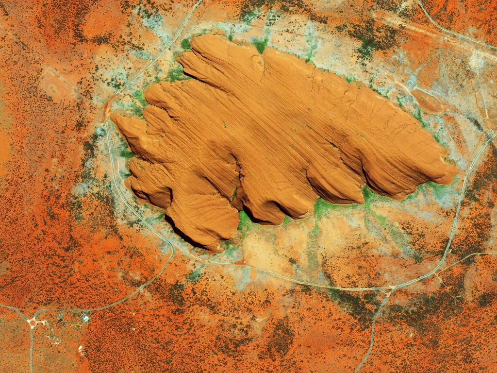
© Mapbox © OpenStreetMap Improve this map
These binaries (installable software) and packages are in development.
They may not be fully stable and should be used with caution. We make no claims about them.
Health stats visible at Monitor.